Government of Assam in recent years has given major thrusts in development of road infrastructure in the state. This has resulted in the growth of road accidents and fatalities in the state and has become a matter of major concern. The road accident data for the past few years is indicative of the growth in road accidents and fatalities in Assam.
| Year | No. of Accidents | No. of Fatalities | No. of Injuries |
|---|---|---|---|
| 2012 | 6535 | 2291 | 6709 |
| 2013 | 7211 | 2441 | 6609 |
| 2014 | 8872 | 3058 | 7787 |
| 2015 | 6959 | 2397 | 7068 |
| 2016 | 7435 | 2572 | 6127 |
The data furnished is also indicative of the severity of the crashes: 35 persons killed/100 accidents
GOA therefore took initiative to develop the Assam Road Safety Action Plan (ARSAP) involving all Stakeholder Departments under the five Pillars of Road Safety to address the issue of fatal and serious road accidents. ARSAP was prepared as per UN Decade of Action and approved by the State Road Safety Council under the chairmanship of the Hon'ble Chief Minister of Assam during its meeting held on 8th January, 2015.
Pillar 1: Road Safety Management -Institution and Capacity Building
Pillar 2: Safer Roads and Mobility
Pillar 3: Safer Vehicles
Pillar 4: Safer Road Users through Education, Awareness and Enforcement
Pillar 5: Emergency Care
Under the Assam Road Safety Action Plan (ARSAP), Govt. of Assam has accorded high priority to the achievement of road safety improvement in Assam. Key actions are already being taken by GOA to begin strengthening of institutional framework, building capacity of the stakeholder departments, strengthening enforcement and improving engineering measures.
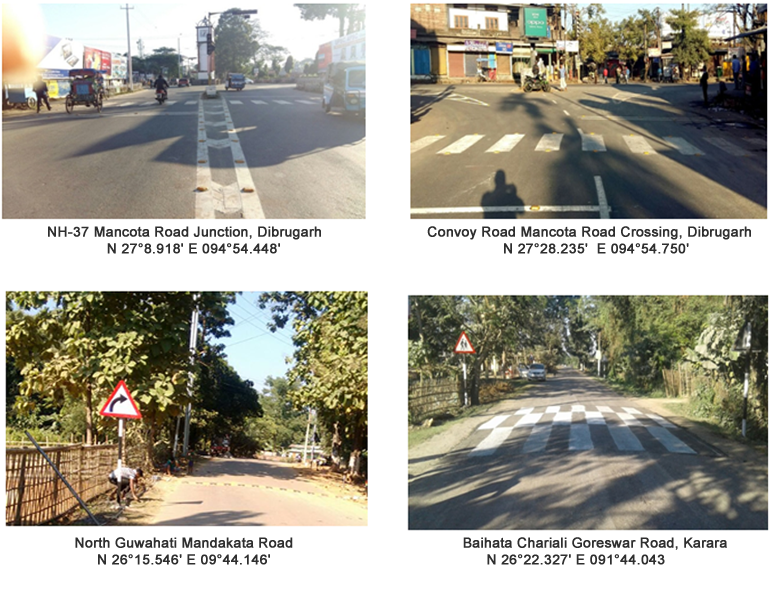
PWRD, Assam under the Road Safety Management Component of World Bank aided Assam State Roads Project (ASRP) has initiated a number of activities for improvement of Road Safety on its State Highways and Major District Roads. This has been done.
| Sl. No. | Name of the Road | Road Length in Km | Chainage | Location | No. of Accidents | No. of Fatalities | No. of Injuries | District | Division | |||||||||
|---|---|---|---|---|---|---|---|---|---|---|---|---|---|---|---|---|---|---|
| 2012 | 2013 | 2014 | Total | 2012 | 2013 | 2014 | Total | 2012 | 2013 | 2014 | Total | |||||||
| 1 | North Guwahati Mandakata Road (MDR) | 22 | 9756.00 m | N 26°15.546' E 091°44.146' | 8 | 6 | 14 | 5 | 5 | 10 | 3 | 2 | 5 | Kamrup (Rural) | Guwahati Roads Division | |||
| 2 | Baihata Chariali Goreswar Road (MDR) | 21 | 3200.00 m | Karara N 26°22.327' E 091°44.043' | 2 | 2 | 3 | 7 | 1 | 2 | 3 | 3 | 1 | 1 | 5 | Kamrup (Rural) | Rangia Rural Roads Division | |
| 7200.00 m | Bihdia N 26°24.499' E 091°43.718' | 1 | 3 | 4 | 8 | 1 | 3 | 1 | 5 | 3 | 3 | |||||||
| 3 | Bordumsa Digboi PWD Road | 36 | 1st km | Madhavpur village N 27°23.723' E 095°37.024' | 2 | 3 | 5 | 2 | 3 | 5 | Tinsukia | Tinsukia State Roads Division | ||||||
| 4 | SH-23 | 5 | 1.5 km | Napukhuri Bus Stand N 27°28.825' E 095°20.055' | 1 | 1 | 3 | 5 | 1 | 1 | 1 | 1 | Tinsukia | Tinsukia State Roads Division | ||||
| 5 | Convoy Road Db-M-1 | 5.3 | 5.3 km | NH-37 Convoy Road Juncion N 27°28.396' E 094°53.694' | 2 | 15 | 3 | 20 | 2 | 5 | 3 | 10 | 4 | 12 | 5 | 21 | Dibrugarh | Dibrugarh Rural Roads Division |
| 6 | Mancotta Saraighat Bamunbari Road Db-M-2 | 33 | 400 m to 600 m | Thana Chariali N 27°28.860' E 094°54.462' | 16 | 14 | 4 | 34 | 6 | 4 | 4 | 14 | Dibrugarh | Dibrugarh Rural Roads Division | ||||
| 1.7 km to 1.9 km | Chowkidingee Charali N 27°28.235' E 094°54.750' | 12 | 5 | 1 | 18 | 1 | 1 | 2 | 3 | 4 | 3 | 10 | ||||||
| 7.5 to 8.1 km | Thakurthan Area N 27°24.935' E 094°55.542' | 3 | 4 | 5 | 12 | 1 | 1 | 3 | 4 | 4 | 11 | |||||||
| 7 | A. T. Road | 3rd km | Baruachariali N 26°445.064' E 094°10.947' | 6 | 2 | 1 | 9 | 2 | 1 | 0 | 3 | 4 | 1 | 1 | 6 | Jorhat | Jorhat State Roads Division | |
| 6th km | Charigaon Road Jn. Point N 26°46.198' E 094°14.429' | 8 | 2 | 10 | 20 | 5 | 1 | 7 | 13 | 3 | 2 | 3 | 8 | |||||
| 6th km | Bamungaon Junction Point N 26°46.385' E 094°14.986' | 4 | 8 | 9 | 21 | 1 | 3 | 6 | 10 | 3 | 5 | 6 | 14 | |||||
| 8 | Silchar Kalain Road (MDR) | 1 km | N 24°50.246' E 092°46.884' | 2 | 3 | 5 | 3 | 3 | 9 | 9 | Cachar | Silchar NEC Division | ||||||
| 19 km | N 24°55.668' E 092°38.912' | 1 | 5 | 6 | 1 | 1 | 1 | 4 | 5 | |||||||||
| 22 km | N 24°57.380' E 092°36.533' | 1 | 6 | 7 | 2 | 1 | 3 | 1 | 5 | 6 | ||||||||
| 28 km | N 24°58.062' E 092°34.399' | 4 | 3 | 7 | 2 | 2 | 2 | 3 | 5 | |||||||||
| Total | Black spots on SH & MDR = 16 | 55 | 74 | 69 | 198 | 12 | 23 | 32 | 67 | 30 | 51 | 47 | 128 | |||||

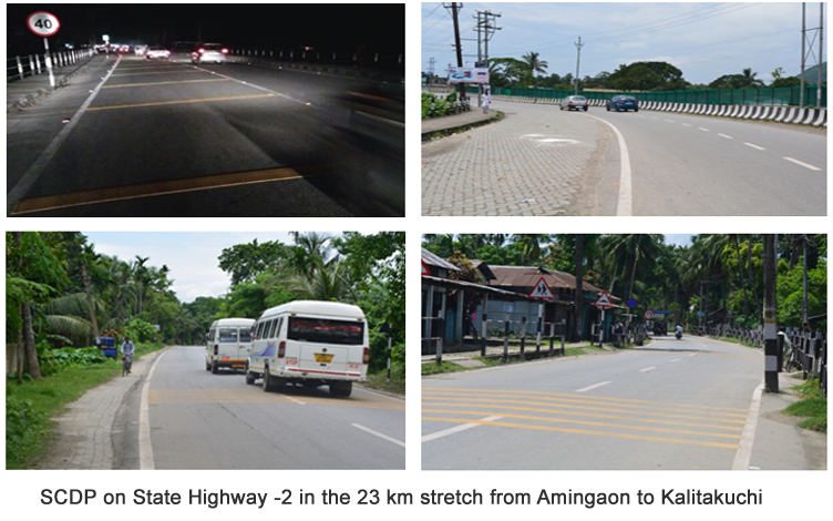
PWRD has developed 23 km of SH-2 (Amingaon to Kalitakuchi) as Safe Corridor Demonstration Program (SCDP) as per provision of Loan Agreement of ASRP. The implementation of road safety measures include:

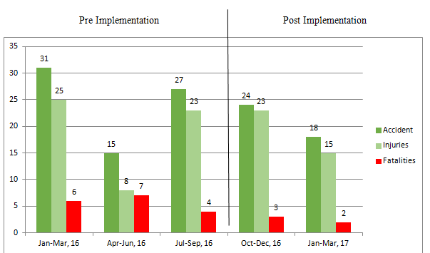
The quarter-wise road accident data collected from concerned police for this SCDP show a decline in the no. of road accidents and fatalities in the post implementation period.
| Quarter | Accident | Injuries | Fatalities |
|---|---|---|---|
| Jan-Mar, 16 | 31 | 25 | 6 |
| Apr-Jun, 16 | 15 | 8 | 7 |
| Jul-Sep, 16 | 27 | 23 | 4 |
| Oct-Dec, 16 | 24 | 23 | 3 |
| Jan-Mar, 17 | 18 | 15 | 2 |

Model safe Corridor Demonstration Programme (SCDP) with Traffic System Management has been taken up for 23 km of Guwahati city from Jalukbari to Khanapra via MG Road-AT Road-GS Road. The consultant ISAN Corporation, South Korea has submitted the final improvement plan for traffic system management which includes congestion management, parking management, access management system, improvement of intersections, pedestrian safety, traffic accident inventory and mitigation.
Implementation of improvement measures shall be taken after the consultant submits the DPR.
Draft Investment Plan for iRAP survey has also been submitted by the Consultant for improving the present star rating of the corridor to next higher star rating.
| Title | Size | Detail |
|---|---|---|
| Road Safety Notification | 590.09 KB |
